New base map and up-to-date water depths

Water Map Live features a beautiful new base map with a wealth of water depth information. Here's how to interpret this data for different bodies of water.
Dutch Version 🇳🇱 | German version 🇩🇪
Most of the data in the tidal areas comes from the IENCs (Inland Electronic Navigational Charts) of
Rijkswaterstaat, which can be read like nautical charts anywhere in the world. The water depths are
shown relative to the LAT water level (Lowest Astronomical Tide). This indicates the lowest
level that the tide can reach under the influence of the sun and moon. This means that you will
usually have a little more water under your keel than this. The current live water level relative to
LAT can be found via the yellow/black gauge icons.![]() (also at
sea).
(also at
sea).
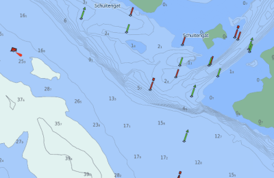
As an example, take this stretch of sea just off Terschelling (see the Water Map for
a live map of this location).

Water depths are shown in metres, with the small number being the decimal point. Light colours
indicate depths of 30 metres or more, light blue indicates depths of 2 to 30 metres, and dark blue
indicates depths of 0 to 2 metres. Areas higher than 0 metres are green and are indicated by a line
below the number. Also note the depth lines: if they are close together, there is a significant
difference in depth.
Large rivers and inland waterways
In inland waterways and on large rivers, there are of course no (or hardly any) tides, but water
levels do fluctuate greatly on an irregular basis. Therefore, LAT is not used, but rather the bottom
height relative to NAP. This is a simple and fixed value that makes it easy to calculate, but it is
important to remember that the figures do not indicate the water depth, but rather the bottom
height. On waters where the water level is equal to NAP, this still means the exact water depth, but
in other places it is best to look up the current water level. This can be done in the app via the
yellow/black gauge icons.  . As an example, this
piece of the Bieschbosch:
. As an example, this
piece of the Bieschbosch:

The figures are all negative, which means that the bottom is below sea level. In the port of
Moerdijk, you will find the gauge for this area and the NAP value of the water
level. Calculate the values and you will have the exact water depths for this moment.
In this perspective it is interesting to see what happens in Limburg, where all values are above sea
level. Near
Roermond, for example, you will find values of around 11 metres in the Meuse.
At the time of writing, the water level is 17 metres above NAP. So it is now 6 metres deep
there.
The Frisian Lakes
The water level in virtually the whole of Friesland is kept constant at -52 centimetres below NAP.
This means that it is possible to work with the actual water depths there. These are therefore
included in the Province of Fryslân's sounding files, and we have incorporated them into Water Map
Live. These values are very easy to read, as shown in this section of the
Heegener Meer:

So -2.5 means that it is 2.5 metres deep, and so on. It couldn't be simpler.
Other waterways
The water depths/bottom heights are determined by means of soundings carried out annually by
Rijkswaterstaat, the provinces, water boards and a few municipalities. Where this data is available,
we have added it to the water map. Is there no data available for your favourite waterway? Then this
data has not been collected and/or made available by the acting authority. We still have data
requests pending with various authorities. As soon as this data comes through, you will see it
appear on the map.
Enjoy Water Map Live!